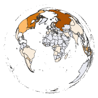
Country-level Land Cover Transitions (CLCT) has information about transitions (net changes) of the land cover categories areas (in km2) on a country level over five-year periods. Positive values indicate an increase of the given land cover category area and negative values indicate a decrease of the given land cover category area. You can download the data files for different five-year periods between 1992 to 2015.
| First year | Last year | File | First year | Last year | File |
|---|---|---|---|---|---|
| 1992 | 1997 | clct_1992_1997.gpkg | 2002 | 2007 | clct_2002_2007.gpkg |
| 1993 | 1998 | clct_1993_1998.gpkg | 2003 | 2008 | clct_2003_2008.gpkg |
| 1994 | 1999 | clct_1994_1999.gpkg | 2004 | 2009 | clct_2004_2009.gpkg |
| 1995 | 2000 | clct_1995_2000.gpkg | 2005 | 2010 | clct_2005_2010.gpkg |
| 1996 | 2001 | clct_1996_2001.gpkg | 2006 | 2011 | clct_2006_2011.gpkg |
| 1997 | 2002 | clct_1997_2002.gpkg | 2007 | 2012 | clct_2007_2012.gpkg |
| 1998 | 2003 | clct_1998_2003.gpkg | 2008 | 2013 | clct_2008_2013.gpkg |
| 1999 | 2004 | clct_1999_2004.gpkg | 2009 | 2014 | clct_2009_2014.gpkg |
| 2000 | 2005 | clct_2000_2005.gpkg | 2010 | 2015 | clct_2010_2015.gpkg |
| 2001 | 2006 | clct_2001_2006.gpkg |
Each download is a spatial vector (GeoPackage, “.gpkg”) file containing 248 observations (countries or territories) and 13 variables:
- ISOCODE - Three-letter country/state code
- UNSDCODE - United Nations standard country or area code for statistical use
- NAME0 - English country/state name
- Years_transitions - First and the last year in the dataset
- Agriculture - Change in agricultural areas between the first and the last year (in km2)
- Forest - Change in forest areas between the first and the last year (in km2)
- Grassland - Change in grassland areas between the first and the last year (in km2)
- Wetland - Change in wetland areas between the first and the last year (in km2)
- Settlement - Change in settlement areas between the first and the last year (in km2)
- Shrubland - Change in shrubland areas between the first and the last year (in km2)
- Sparse_vegetation - Change in sparse vegetation areas between the first and the last year (in km2)
- Bare_areas - Change in bare areas between the first and the last year (in km2)
- Water - Change in water areas between the first and the last year (in km2)
Below you can also download the Country-level Land Cover Transitions data in a tabular form.
| Variable | File |
|---|---|
| Country-level Land Cover Transitions (CLCT) | clct.csv |
Citation:
Nowosad J. (2019). Country-level Land Cover Categories and Transitions. DOI: 10.17605/OSF.IO/RKNV2
